
I first learned of Street-Complete here and I really like it.
It’s satisfying to walk around, complete little tasks, and get prizes, scratching a similar itch to Pokemon Go.
Stuck waiting for someone? Add opening hours for a few local businesses.
Have a long walk ahead of you? See if you can add/check house addresses as fast as you can walk.
Want to walk off a few beers before heading home? Complete some tasks in the bar street.
Its a very constructive way to “be right” on the internet.
I will give it a shot today.
Fdroid says that it is bound to jawg.io for tiles. What are the chances that we are giving our data to a company who will take it away from us, or is just using us for free labour?
@jaxxed @vatlark @openstreetmap
Very slim. But their privacy policies are online if you’re concerned.You free labour all goes to the OpenStreetMap database licensed under the Open DataBase License.
Yes, you link your OSM account to StreetComplete and it adds your contributions via your OSM account. Same with Vespucci.
When you log into OSM you can see all the contributions pushed by StreetComplete.
or is just using us for free labour?
It pushes updates to openstreetmap.
It is free labor. However it benefits us all and there isn’t any alternatives. I don’t think OSM is going anywhere soon. It is has benefits for any people and industries.
Fun fact OSM has had lots of issues with hostile take overs. They now have a dedicated committee on the subject https://osmfoundation.org/wiki/Special_Committee_on_Takeover_Protection
Can I throw in that once you get your stride with Streetcomplete you’ll love Every Door where you can add Shops and features pretty easily. They really complement each other.
@abeorch @vatlark Also have a look at https://mapcomplete.org
Im also interested in Mangrove Reviews. Have to find more out about that.
Thank you for the tip. Installed.
Ta add another one: StreetMeasure. But I think that will be suggested in SC if you don’t have it installed?
Yes … StreetMeaure is very useful - Though I’d prefer it to be available from F-droid - I wonder why its not? Same developer right?
I looked it up in F-Droid. It is only available in the IzzyOnDroid repo. StreetMeasure relies on ARCode and the Google Play Services for AR, so it is against F-Droids inclusion policy.
i wondered something like that. Its a useful tool Obviously prefer not to be using Google Play Services but compromise makes the world go round. Better that than using Google Maps all the time.
I tried it when someone posted about it a couple of weeks ago. It is fun, my son and I go for walks and I include him in the tasks. Unfortunately, we get a lot of road surface questions which are a bit boring.
Same here!
Iirc, you can deselect road surfaces in the settings somewhere so the app doesn’t ask about it?
Yea but somebody gotta add that info ;)
@stiephelando @vatlark @openstreetmap
If a question type gets tedious you can disable that “quest” in the settings.
If a question type gets tedious you can disable that “quest” in the settings.
That improved my experience. I disabled the things that my city generally doesn’t have, and it made my questing much more enjoyable.
If I disable the 3 types of quest I get in my area (road surface, lanes, power pole type) then I get basically no quests, period
I’ve taken to adding buildings that I’m surprised they didn’t already have on OSM and then filling in the quests that auto-populate with that, but its meh
Have you looked at all the different layers? A while back they added more of those, with different types of quests that don’t appear normally.
You can also add “little” objects like benches, recycling containers or trees in your near environment to the map that come with their own sets of questions
The road surfaces actually help a ton for apps that come up with bicycle routes as well as those on wheelchairs. However of you’d prefer less of them, you can make jt a lower priority in the settings.
I don’t like the implication that Pokémon GO was bad when it got a ton of people to go outside and interact with each other. This is cool too though.
That’s a great point. I probably could have worded that differently.
It wasn’t bad. Now. It is.
This does not. Make. Any sense.
Time exists. Things change over time. Shocking revelation I know
It was unique time and experience at its peak. People moved on largely and if something as big and addicting as Pokémon couldn’t permanently make it popular then nothing will
It will come back however in different form as the miniaturisation of VR headsets progresses and whenever it will be cool and comfortable to walk in one
Walking with eyes glued to phone gets old real quick and can fucking kill you hence no matter how good game is this formula is dead. Many Darwin awards were handed out. My friend received one and another got just a nomination
I know the E word is getting old here but I’ll say that “product degradation” occured for the reasons of increased revenue
@RealFknNito @vatlark @openstreetmap
It caused a lot of fake stuff to be added to OSM even though its update frequency was slow enough that very little of the fake stuff actually made it into Pokemon Go.
I think it did bring in a few good mappers too though so it wasn’t all bad.
StreetComplete to the polls
Why does F-Droid tell me that the app has features that I may not like?
If you expand the description it will be written out for you.
It is due to being bound to a specific mapping Ecosystem and using specific non Foss middleware
It is because it has what F-Droid considers anti-features. In this case, even tho the code is open source, it seems to require a non-libre dependency to measure distances. See https://gitlab.com/fdroid/fdroiddata/-/issues/2627 and https://github.com/streetcomplete/StreetComplete/pull/3709#issuecomment-1039710672.
F-Droid is very strict with what it considers an anti-feature, and Android is very restrictive to properly work without at least one closed source library (thanks, Google), so I say you can ignore this, but it depends on you.
Also, openstreetmap itself is a centralized eco system, even though you could theoreticallly host one yourself.
@Danitos @AngryCommieKender @openstreetmap
IIRC that was pulled out of the app into a separate companion app (StreetMeasure) ages ago.
F-Droid is complaining about “non-changeable or non-free network service”.
It doesn’t seem to say _which_ network service this is, which I think is quite scummy behaviour TBH.
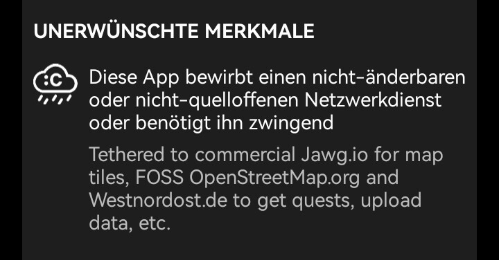
to me it looks like it’s pointing out the network “services”:
and to me it also looks like they also say what the sercives are needed for. however its in german for this device.
update:
it sounds a bit weird that according to this info not the app is uploading new informations, but westnordost.de would, which suggests that they also upload/steal your openstreetmap password to their servers instead of using the app with locally stored access credentials to do that. but this could also be just a bad wording/misunderstanding/translation thing as obviously the party where you download the quests also need to know which quests are already solved which would be the data that is uploaded to them.
@smb @openstreetmap
In my browser that can’t be expanded and clicking on it just takes you to their definition of “Non-Free Network Services” https://f-droid.org/en/docs/Anti-Features/#NonFreeNetSo they’re complaining that an OpenStreetMap app is tied to OpenStreetMap related services and hiding this in a way that makes it look worse than it is.
This dramatically lowers my opinion of F-Droid.
maybe the browser version isn’t fully complete, or there might be a thing with css, bad browser specialities, just a bug in the webpage (did you check if it does show up in page source plaintext maybe?)
i would see the warning "bound to a specific non-changeable service as a good thing, as it would promote completely-free apps like (i think) fluffy chat, which does neither depend on a specific matrix service nor on a specific push service (i.e. it uses ntfy for push when installed, and if i choosed to use my own instance it would - i think - use that instead of the default ntfy.sh) in theory everyone could run something like osm and in practice this could come in very handy in the future one day, but currently IMHO only one osm exists, so maybe its not that bad for an app to be bound to it, but its always good to know if an app is bound or free to choice, same i would like to know if its maybe multi-account (which fluffy-chat is), but single-account-apps are so very common and thus this is not seen as an anti-feature which is completely ok for me.
but also in this case here the app is not only bound to osm, but to two other non-changeable services too, thus the warning is due even if label-app-bound-to-label-service would NOT be considered an anti-feature.
@smb @openstreetmap
If I view source I get “phrase not found” on a search for “Jawg” . It also doesn’t show up in Firefox’s Inspector, which I _think_ includes dynamically loaded stuff.Just checked Chrome and Microsoft Edge and they don’t show it either. What are you using to actually get the detail?
I wouldn’t mind F-Droid’s warning if they gave me the details, but for some reason they don’t seems to be accessible to me.
1/2
I don’t know how you’d get round the dev using his own site to pre-process (already published) data or host a list of “banned versions” with bugs that could corrupt data. You can’t really choose to have a different developer on the fly.
Maybe you could let people chose a different host for a published photo, but I think if there were privacy respecting ones that easily allowed that the dev probably would have use those instead?
https://streetcomplete.app/privacy
2/2
What are you using to actually get the detail?
i am using the F-Droid “app” (currently 1.20.0), not a browser now. But i asumed css or such could be a cause as sometimes nonvisible content is behind some bad (ad?) layer. i thought i had seen such infos also on their website, but that is then too long ago and i might just be wrong with that.
maybe you can only get that info from the app which would feel a bit like an anti feature *haha
RE the update. That seems odd that they’d do that. I thought the quests were now being generated on the fly after downloading the raw data direct from OSM (previously it was an overpass query per quest IIRC).
I don’t know why they’d be bouncing uploads through a remote server when OSM already has the capacity to reject a conflict.
I don’t currently have access to something that monitors raw traffic to check.
Because it tracks real time location and uses the internet. Unless it’s an app like this where you explicitly want that functionality, that’s usually a sign of some sort of tracking mechanism for advertising or nefarious purposes.
That just is not what F-Droid is saying. Why would you even claim that?
Non-Free Network Services
This Anti-Feature is applied to apps that promote or depend entirely on a Non-Free network service, or any service which is impossible, or not easy to replace. Replacement requires changes to the app or service. This antifeature would not apply, if there is a simple configuration option that allows pointing the app to a running instance of an alternative, publicly available, self-hostable, free software server solution.
Because you can’t change it from using OpenStreetMap.org to an alternative self hosted site.
I love this app, found it a bit ago on F-Droid. I’m moving to a very rural town up north and there’s nearly nothing done there. Very excited to get up there and start working on it.
every time i find myself in a rural town, i go out for a walk with streetComplete. I’m often the first mapper of those areas and it’s a pleasure to complete the map and see your entries on the updates a couple of weeks later. next time you’re there, you have a detailed map of the area available and you know why :)
Explaining your OSM addiction to friends and family is a little harder. “I just need to spend the entire day mapping”
“don’t wait for me, keep walking. i have to answer these questions”
😅
@VirtualOdour@sh.itjust.works had a great idea in their comment above - fill in what you can, then use OSM to add missing buildings etc. They explain it better here though
!https://sh.itjust.works/comment/12811829
I do it but in Paris there are way too many things to add, so it feels too much most of the time
Thanks a lot for the suggestion, it’s quite fun and I’d love a future where OpenStreetMap data is exaustive
It already is better than Google in some areas. For instance, it has way more information on hiking trails.
Pretty sure they’re used for RideGPS, too.
It is actually pretty fun. However it can’t do everything. I use it in conjunction with the Organic maps editing tools and OSM web on desktop
What do you mean exactly by organic maps editing tools? I was using organic maps before to add businesses, but now StreetComplete can also do that (and more!). I sometimes use Vespucci because it is very powerful, but it’s a bit of a pain to use.
Yeah I still can’t figure out how to add a postal box in StreetComplete so I use Vespucci. But yeah Vespucci is intimidating at first
@vatlark @Scafir @openstreetmap
The postbox thing is apparently an issue with the presets they use. The presets are from another project so it’s considered “blocked”.
https://github.com/streetcomplete/StreetComplete/issues/5584
+1 for vespucci being intimidating. Mainly cause I feel like I need to read a variety of wiki posts before modifying a new feature type. But once you start to get the hang of it, it really pays off.
It can create arbitrary points
While StreetComplete is very careful with the quests, my experience with SCEE was much worse. As an example, with with current SCEE 58.2 the building color quest is still buggy. The brown, black and white choices are showing wrong colored illustrations.
Therefore SCEE is not a recommendation for me.
@redd @Andromxda Did you mention this on GitHub? That should be solvable.
Friendly PSA that there is also StreetComplete ExpertEdition (on F-Droid only) which as more tasks and crucially allows you to directly edit tags. Very recommended if you know what you’re doing and have some more familiarity with OSM.
https://github.com/Helium314/SCEEOh, this is interesting. I’m not the most advanced OSM user, but I’ll definitely take a look at this and learn.
iOS version is in the works but there’s something similiar online too.
I’ll recommend this to my wife who plays Pikmin Go religiously.
@MonkderDritte @vatlark @openstreetmap
@MapComplete is only similar in that it is aimed at giving simple tailored forms to new users. It does not make it easy to contribute “all the low hanging fruit closest to me”.
StreetComplete is godsend. Editing OSM in JOSM, iD, etc, is not trivial and involves reading a lot of documentation and forum posts (if you care to do things right), which of course isn’t anywhere near practical for small devices when you’re on the go, surveying.
This app changed my whole routine. The interface is really solid and helps the community target important tasks, rewarding it with little prizes. Althewhile, the gamification is kept at a very healthy level, to avoid attracting leaderboard seekers and whatnot, which would certainly lower the quality of contributions.
I think the contribution day grid (akin to GitHub’s thing) as well as the dynamic category explorer, the badges and the OSM-related projects it reveals to you bit by bit really being everything together. It’s an incredible tool!
For the experienced (and this is not said lightly), there is the expert version, which adds more advanced editing features for those looking for a bit more control in regular SC.


